With its 1753 m in height, the Mont Mézenc is one of the unmissable of the region. Near the sources of Loire, it is situated between Ardèche and Haute-Loire, offering a view at 360° on the mounts of Ardèche, Velay, and the volcanic plateau of the Devès and the massif of Meygal.
To hike and discover this territory, 28 tracks are available. Their lengths vary between 45 minutes and 5 hours, are certified Respirando and marked in yellow by the local council communities. To walk this hiking trails, three possibilities:
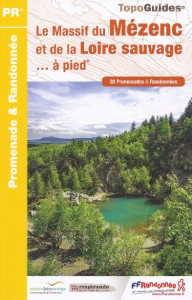
The guidebook of the « Pays du Mézenc et de la Loire sauvage » (front cover opposite) includes the entirety of the 28 walks. One can find:
Of a format of 13.5 x 21 cm, the Topoguide has an ideal format to discover a territory as a whole.
>> To get the guidebook of the « Mézenc et Loire sauvage », go to our online shop, in the section “randonnée à la journée”.
Among these walks, 14 tracks are also available in the form of individual cards: the Randofiches. Each Randofiche includes one track and is enriched with:
With their handy format (10.5 x 15 cm), you can easily put them in your pocket and, as they’re printed on a tearproof and waterproof paper, they’ll resist any kind of bad weather.
>> To get the Randofiches of the « Mézenc et Loire sauvage », go to our shop online, in the section « randonnée à la journée ».
14 tracks of the guidebook are also available under a digital format (free download). Each digital Randofiche includes one walk and is enriched with:
Thus, you can easily download them on your smartphone or print them at home. To download them, simply click on the links below:
PR 58 le tour du mont Alambre – PR 61 le lac de Saint-Front
PR 80 l’oratoire Saint Roch – PR 592 la vallée de l’Aubepin
PR 586 la balade de la burle – PR 583 la draille des muletiers
PR 581 le moulin du rocher – PR 577 entre Loire et Gazeille
PR 491 circuit de Clauzelles – PR 489 balade de la douce
Cliquez sur les marqueurs pour afficher le détail du circuit


Circuit de Clauzelles : belle balade faite le 15 juin après les fortes pluies du we précédent. Agréable et bien balisée. Un passage très herbeux après le hameau de Clauzelles lorsqu’on remonte.
Bonjour, quelqu’un connait-il le circuit des gorges de la monette ? Est-ce le circuit du marais ? C’est vers les Vastres.
Bonjour ! Oui, les gorges de la Monette sont accessibles en suivant le circuit du Marais qui part des Vastres. Bonne journée.