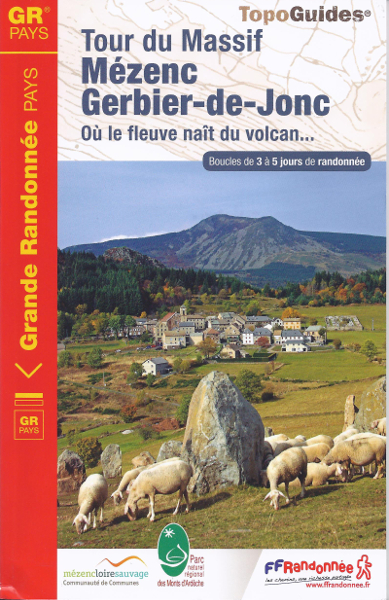
From the sources of Loire to the summit of the Mézenc
From the sources of Loire to the summit of the Mont Mézenc (1753 m), you will be able to make a hike in 3; 4 or 5 days according to the route chosen. Of a length of 111.5 km, the main loop will lead you between Haute-Loire and Ardèche, with views on the high plateaus of the Mézenc and the Regional Park of the Mounts Ardèche. Oh and, by clear weather, the view will even be clear till the Alps…
Your stopovers on the GRP Tour of the Mézenc Gerbier-de-Jonc
 The tour of the Mézenc – Gerbier-de-Jonc includes a main loop and a diagonal allowing to build 3 distinct itineraries from 3; 4 or 5 days (see route opposite). We offer you, below, an example of possible stopovers:
In 3 days, from Chaudeyrolles
- Day 1 from Chaudeyrolles to Sagnes-et-Goudoulet, 27 km (about 6h45 of walk) by the North-South diagonal,
- Day 2 from Sagnes-et-Goudoulet to Borée, 23.5 km (around 6h of walk) by the East branch,
- Day 3 from Borée to Chaudeyrolles, 23 km (around 5h45 of walk) by the East branch then by the diagonal.
In 4 days from Freycenet-la-Tour
- Day 1 from Freycenet-la-Tour to Béage, 21 km (around 5h15 of walk) by the West branch,
- Day 2 from Béage to Villevieille, 10 km (around 2h30 of walk) by the West branch,
- Day 3 from Villevieille to Fay-sur-Lignon, 22.5 km (around 5h45 of walk) by the South-North diagonal,
- Day 4 from Fay-sur-Lignon to Freycenet-la-Tour, 23 km (around 5h45 of walk) by the West branch.
In 5 days on the main loop from Freycenet-la-Tour
- Day 1 from Freycenet-la-Tour to Beauregard, 17 km (4h15 of walk),
- Day 2 from Beauregard to Sagnes-et-Goudoulet, 26.5 km (6h45 of walk),
- Day 3 from Sagnes-et-Goudoulet to Borée, 23.5 km (around 6h of walk),
- Day 4 from Borée to Fay-sur-Lignon, 17.5 km (around 4h30 of walk),
- Day 5 from Fay-sur-Lignon to Freycenet-la-Tour, 23.5 km (around 6h of walk).
Accommodation and services
Accommodations are available on the Tour of the massif Mézenc – Gerbier: bed and breakfast, stopover gîtes, campsites or even hotels. You will find a list of these service providers in the guidebook, the useful guidebook of the accommodation or even our dedicated page about the accommodation. Do not hesitate to contact them to book from now on your stay.
For the luggage or people transportation, la Malle Postale offers this walk in its catalog. You can also consult our other partners who will draw up a quote for you.
The guidebook of the GRP Tour Massif Mézenc – Gerbier-de-Jonc
 The Topoguide is essential to prepare your hike. It contains the supplies chart to prepare your stop-overs, a list of the accommodation, the IGN maps and the description step by step as well as explanatory sheets about the fauna, flora, heritage…
The IGN maps of the itinerary
The IGN maps are already included in the guidebook. Nevertheless, if you wish a more global view, the matching IGN maps are the following ones:
- 2836 OT Gerbier-de-Jonc Mézenc
- 2837 OT Lac d’Issarlès
- 2936 O Le Cheylard
- Global view on the IGN map, scale 1: 100 000 Ref. 156 Le Puy – Privas
Access to the GRP Tour Mézenc –Gerbier-de-Jonc
The itinerary of the hike is situated on the mountain range at the South-East of Le Puy-en-Velay, between Haute-Loire and Ardèche. From Le Puy-en-Velay, the village the most quickly reachable is Freycenet-la-Tour: 30 minutes drive.